
- Operating in IMC and in bad weather, regardless of your skill and training will increase your workload. It is important therefore to pre-brief if possible and certainly to methodically plan approaches – re-briefing as you go.
- In this case the passenger was also a pilot (PPL). It is worth considering ways your passenger can reduce your workload. Can they operate the radio? Keep a Lookout, confirm your frequency selections? If the passenger can do none of these things will they get in the way? – Brief them in that case to keep quiet. Note no comment was made re passenger interaction in the AAIB report so these are simply my thoughts on the subject.
- Use of GPS as DME. Certainly has been applicable to ZV as our DME has been unreliable over the last year (it is now fixed but there may be instances when DME fails and you need it in an emergency). GPS is not an approved DME so should be a last resort rather than 1st option. If you MUST use it then make sure the correct waypoint is selected – it seems that G-RICK had selected DND rather than IDDE (failure to brief the approach ?)
- Use of GPS – G-RICK had a Garmin 530 this is not an intuitive piece of kit. If you are not using it often then you are not likely to be familiar with it. ZV has no equivalent and no IMC rated GPS so you shouldn’t become confused – but make sure any waypoints selected are the correct ones
Frequency Ref Cards as Published by NATS
Flight 12 Apr ; Attempt to Overfly Bute
BEZV came back from her Engine change on Friday. With a new engine it is necessary to ensure that it is run-in properly. To this end only straight mineral oil is to be used. There are three bottles in the ZV’s storage box. This is not a multigrade and is like treacle so needs to be poured carefully! We will swap back to AD oil at the next 50 hour inspection.
For first 25 hours at least:
• No PFLs, no stalling exercises, no circuits, no glides, no power off descents.
• Cruise at least 65% power, preferably 75% – check flight manual to find actual RPM required for alt/temp (density altitude).
• Keep engine at full or at least rich of peak rpm – that keeps the CH cool.
• Keep below 8000 feet, preferably 5000 (to generate enough manifold pressure to bed the piston rings into the cylinders).
• Use shallow/high speed climb to help control CHT.
• Plan shallower decent profile to keep power on.
To help run in the engine in its 1st few hours with us I decided that I would take her on a longer run –to Bute and back. Given the restrictions above handling was not as normal e.g. losing height I kept power up and gently lost height at 120 kts. The reason for not planning to land at Bute was to ensure that low power setting were not used unnecessarily.
My Original plan had been to fly to Wickenby, refuel and return which would have put around 5-6 hours on the engine in cruise mode. Unfortunately weather at Wickenby was forecasting crosswind gusts to 45 kts so I went with plan B and an out and back to Bute. On arriving at the club I met with Sandy who suggested the North looked a better bet today given a front that was sitting over the middle of the country (he turned out to be correct although I learned more by heading to Bute).
On take- off crosswinds were strong and I wandered to the left side of the as the nosewheel lifted, an inauspicious start. I was a bit concerned about Aberdeen crosswinds on landing but the forecast showed an improvement by the time I would be returning. Routing via LOS I was cleared not above FL70 and own Navigation to PTH. I stopped climb at FL60 mindful of needing to keep as low as possible but also wanting to remain clear of cloud ahead which seemed to have a base around 2500 ft with tops at 5500.
At Perth I was able to descend to 4000ft and head towards Dunblane. Unfortunately cloud was now in front of me and down to low level so I requested permission to climb from Glasgow and IFR clearance to Bute. Again I wanted to keep as low as possible for engine management purposes but once in cloud started to pick up ice very quickly. I also noted my DI was 30 degrees off! So discretion being the better part of valour I requested reciprocal course and high tailed it out of cloud and back to Perth where I could get down to 3500ft and clear of cloud. Descent was made by keeping power up and increasing speed with a shallow nose down angle as advised. Return to Aberdeen was via the Stonehaven lane at 1000ft a very scenic way to return. On reaching the Girdleness lighthouse Iwas given direct clearance to RW 34 where I made a rather good crosswind landing even if I do say so myself!
Lessons
1. FREDA checks – ZV’s DI wanders more than most make sure its checked regularly and particularly after manoeuvring and before entering cloud.
2. Keep a sharp eye out for ice formation on the airframe
3. Carb Heat – In cloud and with ice forming consider applying even if Revs are high; keep an eye on Revs for signs of power drop off. I noticed this early and obtained descent clearance from Glasgow
Flight 22 Sep 14 – T/O 1700 (local) land 1840 (local)
Route ABZ – Dufftown – Lochnagar –Forfar – Montrose
Weather –Anticyclone; Wind Southerly 7 kts at airfield; Westerly 10-15kts at 4000’; Vis poor to Very Poor when heading west. Had to climb through thick haze and at Dufftown entered cloud at 3500’.
Lessons :
Decision Making at Dufftown just as turn point reached entered cloud; Aberdeen told me to Sqk 7000 and freecall Scottish who then didn’t answer immediately; when they did Squawk changed all equals High Workload. High Ground Around therefore immediate climb to well above Safety Altitidue; Fly the aeroplane – gain height 1st then turn to heading and then deal with ATC ; squawk etc – AVIATE; NAVIGATE; COMMUNICATE
Changing Squawk- Sby and Change and DON’T FORGET back to Alt – Duh!
FREDA checks – DI kept wandering keep an eye on it;
ILS charts keep to hand. Considered ILS recovery but 5 ac ahead so decided to go visual and got in straight away joining downwind for RW16
Aberdeen to Dundee Instrument Approaches 10 June 14
2hrs 25 mins in G-CCTT; 2 x NDB to ILS and 1 NDB approach at Dundee R/W 09; Radar to ILS at Aberdeen R/W 16
T/O at 1647 IFR departure to Dundee; climbing to 4000 ft using GPS initial navigation and then homing to DND NDB; Entered base of CB en route and had significant up and downdraughts ; deal with these by bringing speed back to just under 100 Kts TAS (Turbulence Penetration Speed) . Maintain level by setting level attitude and accept +/- 100ft; if deviation greater then apply nose up or down as required and power – even full if required to climb.
Entry to NDB outbound track at DND with crosswind from the south and slight headwind. Base turn for NDB:
60 degrees to go then 60 degrees Relative Bearing
30 degrees to go then 35 degrees Relative Bearing
Write these onto Approach charts
1st ILS approach OK but with tailwind needed to reduce power more than did 90 kts IAS would be sufficient and 1500 RPM; be prepared to roll out on base turn with 30 degrees to go to allow localiser to come in. Approach down to minima was OK though and landing or circle to land would have been successful
2nd ILS approach spot on the button; 1500 rpm to allow for tailwind and crosshairs in middle all the way down.
Both approaches carried out missed approach as Standard and back to DND no problems.
Final Approach was NDB. Good base turn but watch for intermediate heights; needed more right correction but again a successful approach to minima with Instrument Departure to GLESK then freecall Aberdeen for IFR rejoin.
Handed to Director at Aberdeen and Radar Control to ILS for RW 16. Channel was very busy and Director brought us in tight and down to 1700ft to intercept localiser. Turned through desired heading and had to readjust but no sweat as this was corrected quickly. Landing was flapless though flared alittle too high – correct by holding and applying a little power.
Help points:
1 – Brief each approach and get checks done early and when not busy
2 – Talk myself through the approach including mantra ‘heading and attitude’
DCO
Flight 28 Feb 2014 – Aberdeen – Inverurie Lane – Rothes – Aviemore- Perth – Montrose – Stonehaven Lane – Aberdeen. T/O at 1020hrs land 1135 hrs
With a bright sunny day dawning on 28 Feb after several weeks of dull and wet weather I took the opportunity of making a Cross Country flight over the Cairngorms.
T/O at 1020 with no problems and transited the Inverurie Lane at 1500’. Surprised by pretty heavy buffeting from Bennachie as winds at surface were calm and only 20 kt Westerly at 3000 ft. On clearing INVL decided to climb to 5000’ on Aberdeen QNH (998) to avoid any buffeting from Cairngorms. Handed to Lossiemouth at Keith and transited to Roithes no issues. Surprised that very little snow was on Ben Rinnes as the BBC had been reporting record levels of snow in Scotland. In truth there was a lot of snow on Cairngorms but hardly any elsewhere including the Monadh Liath. Although a bright sunny day in Aberdeen, there was increasing amounts of cloud in the Spey Valley necessitating a climb to 6000’ and some manoeuvring to keep clear of it.
At Rothes I free-called Scottish Info. The leg from Aviemore to Perth had a lot of cloud cover with only fleeting , but stunningly beautiful, views of the ground. Approaching Perth at 5500 ft I checked in to Perth Radio to get understanding of local traffic – unsurprisingly nothing to affect at my height. From Perth it was a descent to 3000ft and then a PFL simulating Engine Failure before free call to Aberdeen Radar for re-join via Stonehaven Lane. There followed quite a bit of orbiting because of busy traffic – Commercial; GA (OF and TT as well as myself ) and Helos – 1st offshore Bridge of Don for 2 orbits and then at end of downwind leg for further 2 orbits before clearance to land. Landed with slight crosswind (9kt) at 1135
Lessons Learned:
Set 2nd Altimeter to 1013 when operating at height (6000’) in order to ensure staying clear of airway base.
PFL ensure land into wind if possible – look for visual clues (nearly calm on the day)
Navigation – Heading – don’t let it wander and if you can see the next point use eyes and go directly!
Flight 11 Feb 2014 – Aberdeen – Inverurie Lane – Dufftown- Banff – Peterhead – Peterhead Lane – Aberdeen. T/O at 1740 hrs land 1910 hrs
A sunny afternoon developed after early rain so I thought I would try to take a look at the Cairngorms at night. T/O at 1740 hrs but found Cairngorms covered in cloud. Also surprised to see close to Aberdeen that there was snow lying at low levels – I had not seen any sign of there having been snow at all during the day.
Once airborne, therefore I had to change my route. As it was clear to the North a clockwise circuit of the NE coast seemed a good option with a bit of GH on the way. Navigation was easy and I stayed with Aberdeen Radar throughout the flight. Given clearance to join the Aberdeen Zone early because of high traffic levels, in retrospect I could have requested further clearance to head South via Stonehaven Lane for further Navex as I had a full fuel load so at least another 3hrs endurance. This might have reduced the load on the Aberdeen controller. After a couple of orbits at Balmedie with good views of ship lights in Aberdeen bay – cleared to join base leg to land, which went fine despite strengthening crosswind.
Lessons Learned / Points to Note:
1 – Could have landed long to get to E1 turn off more quickly or offered to turn off at E6
2 –Beware disorientation – at nights need to use instruments combined with visual cues.
Morse Code Cheat Sheet
Vowel = Dit (.)
Consonant = Dah (-)
A ax
B beau
C cola
D dee
E e
F ooFa
G gra
H ….
I ii
J ojjj
K kim
L oLeo
M mm
N no
O —
P oPPo
Q ssuQ
R (r ) ice
S …
T t
U ear
V oooV
W (w)ank
X heat
Y yank
Z zzoo
Pick your own words but these work for me as mnemomic
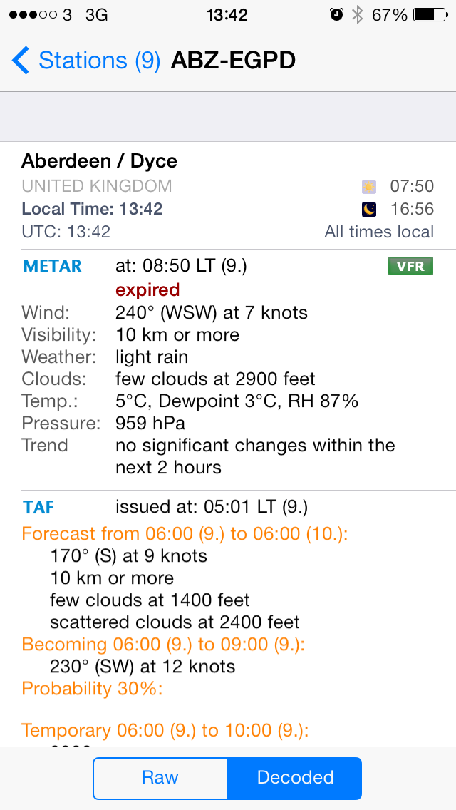
AeroWeather Lite – Free App
A Pro version of this excellent App is available for £2.49, but for my purposes the free Lite version is more than adequate. I have put in a couple of screenshots below. The App provides latest airfield METAR and TAF data from a database of worldwide airfields. Also provided is the local sunrise and sunset times. Personally I have pre-selected my local airfields but you can add and delete as you wish and with Location Services it will provide data from the nearest airfield. I reckon this app is a must for the PPL aviator
ZULU VICTOR Landaway at Bute

